
Story at a glance
- NASA released side-by-side images of the reservoir taken from space in July of 2000, 2021 and 2022.
- The image from July 6, 2000 shows a full lake with a deep shade of blue. The photos from 2021 and 2022 show significantly less water with a lighter shade of blue and light-colored fringes along the shorelines.
- A megadrought fueled by climate change and mismanagement of water resources has led to a sharp decline in Colorado River water levels over the past two decades.
Water levels at Lake Mead, the nation’s largest water reservoir which straddles the Arizona-Nevada border, are at a historic low as a megadrought plagues large parts of the American West.
Now satellite images recently released by NASA show the impact years of worsening drought has had on the reservoir that supplies water from the Colorado River to nearly 25 million people in Arizona, Nevada, California and parts of Mexico.
As of July 18, 2022, Lake Mead was filled to just 27 percent of its capacity and water levels stand at their lowest since April 1937, when the reservoir was still being filled for the first time.
NASA released side-by-side images of the reservoir taken from space in July of 2000, 2021 and 2022. The image from July 6, 2000, shows a full lake with a deep shade of blue. The photos from 2021 and 2022 show significantly less water in a lighter shade of blue with light-colored fringes along the shorelines. These are mineralized areas of the reservoir that were once underwater, referred to as a “bathtub ring.”
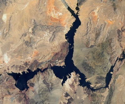
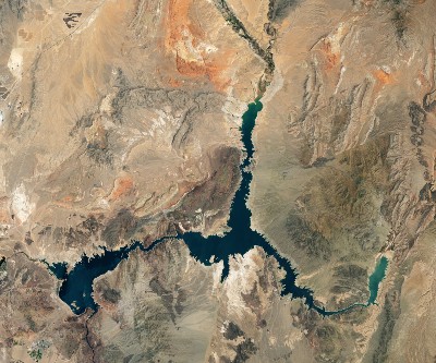
At maximum capacity, water levels at the Hoover Dam would reach an elevation of 1,220 feet above sea level and would hold 9.3 trillion gallons of water. Water elevation at the end of July 2000 was less than 1,200 feet above sea level. According to the U.S. Bureau of Reclamation, water levels dropped to 1,041 feet. Water levels need to stay above 1,000 feet to continue operating hydropower turbines at the dam at optimal levels.
A megadrought fueled by climate change and mismanagement of water resources has led to a sharp decline in Colorado River water levels over the past two decades. A study recently published in Science concluded dramatic steps must be taken to stabilize the river’s resources, including drastic consumption cuts.
changing america copyright.