It’s the first El Niño winter in 5 years. What will be different?

(NEXSTAR) – El Niño is back with a vengeance. After years of back to back La Niña, this winter will be the first in five years with an El Niño pattern in place.
The last time we saw El Niño was in the winter of 2018 to 2019, and even that year’s El Niño was substantially weaker than the one we’re seeing now.
During an El Niño winter, the southern third to half of the United States, including California, tends to see wetter weather. (Exactly where that dividing line falls varies from year to year.)
Meanwhile, the Pacific Northwest and parts of the Ohio Valley tend to be dry and warm. Hawaii also often sees below-average rain during an El Niño year.
La Niña is basically the opposite: less rain or snow for the southern half of the country, and colder, wetter conditions in the Pacific Northwest.
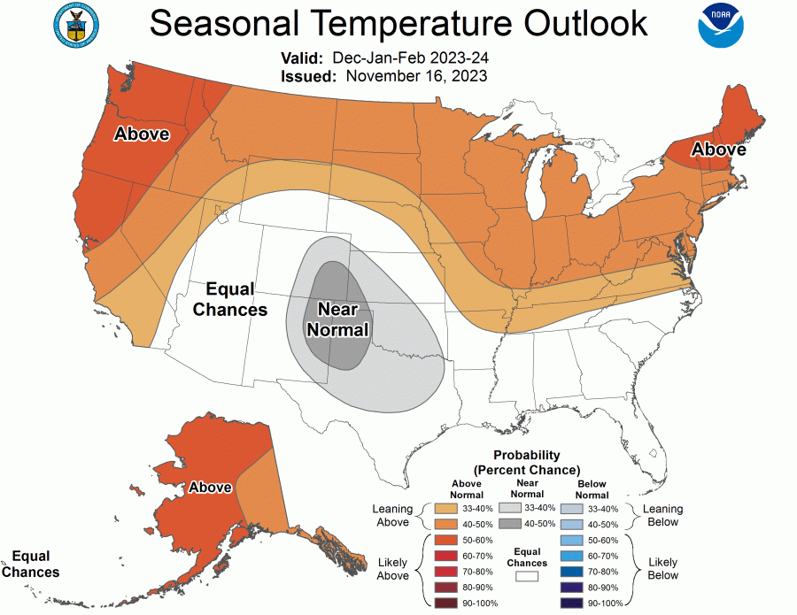
The influence of El Niño shows up in a new long-range winter forecast released by the Climate Prediction Center on Thursday. The maps (below) show about half of the country, from California through the Upper Plains, across the Midwest and up into the Northeast, expecting above-average temperatures between December and February.
The Pacific Northwest, Northern California and New England all have the highest probability of seeing a warmer-than-average winter.
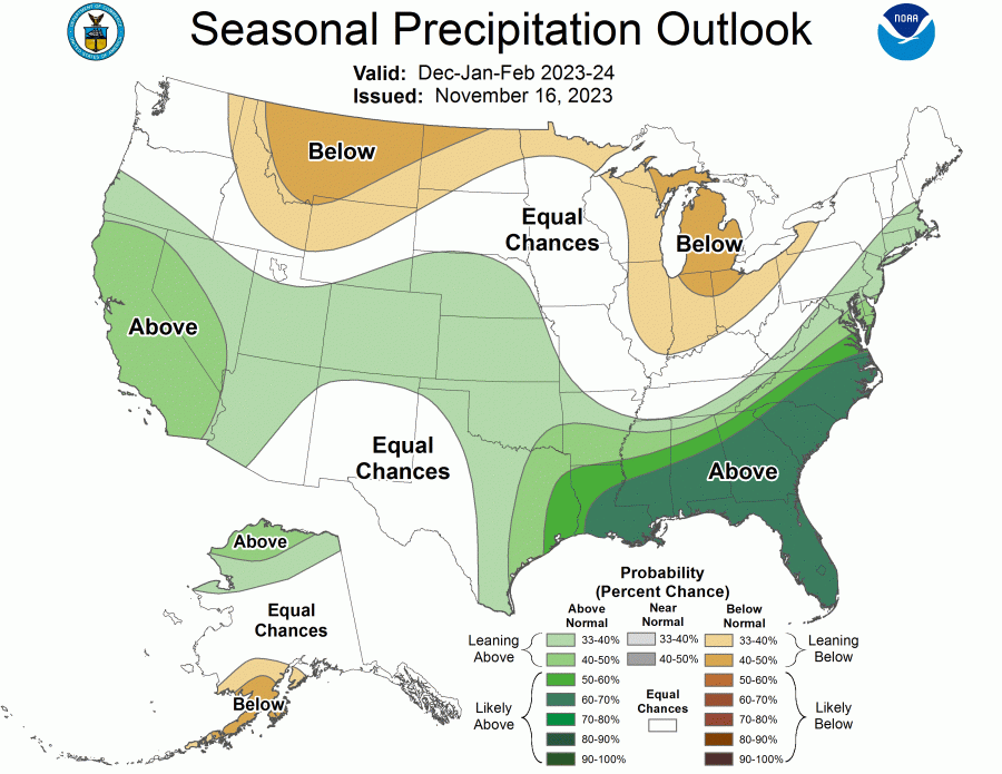
As is expected in an El Niño year, it’s the southern states that look most likely to get hit with rain. The Gulf states have especially high chances – 60% to 70% – of a wet winter.
All of California, plus a large band of central and eastern states, are also leaning toward above-average precipitation.
Meanwhile, a few northern and Great Lakes states are leaning toward less winter precipitation than a typical year.
This year, there is a greater than 55% chance of a “strong” El Niño, national forecasters said last week. There’s even a chance – about 35% – it ends up being one of the strongest ever, like the one we saw 2015-2016 or 1997-1998.
But even a strong El Niño isn’t a guarantee of any particular outcome on the ground.
“El Niño nudges the odds in favor of certain climate outcomes, but never ensures them,” Michelle L’Heureux, a meteorologist with the Climate Prediction Center, recently wrote.
Whether we’re in a La Niña year, El Niño year, or neither is determined by sea surface temperatures near the equator over the Pacific Ocean. The temperature of the water and air above it can shift the position of the jet stream, which in turn impacts the types of weather observed on land.
Copyright 2024 Nexstar Media Inc. All rights reserved. This material may not be published, broadcast, rewritten, or redistributed..


tt
Harris calls for ending filibuster for abortion rights